Tuesday, 21 June 2011

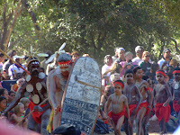
Laura Dance Festival


Uncle Tommy George on left
Laura, Cape York 16-19 June 2011

Our time at the Cape has now come to an end, nicely closed with 3 days in Quinkan Country at the Laura Dance Festival.

This meeting every 2 years of the various Murri and Islander communities from the tip of the Cape to down around Townsville is a major cultural event for these folk where they showcase their cultural lives with each other as well as for big mobs of tourists and travellers like us.  Uncle Tommy George, one of the Traditional Owners of the area and the elder with custodial responsibility for the famed Quinkan art sites, welcomed us to his Country and presided over the 3 days of festivities. Around 500 dance performers compete for the Laura Shield before 5,000 or so visitors – it was a privilege to be amongst them all. 

When you think that the wee hamlet of Laura consists of no more than about a dozen or so buildings, 100s of kilometres from a major town, you may well wonder how they cope with such a huge invasion of outsiders. 

Fifteen kms out of town is the camp ground where the festival is held, nestled amongst the granite and sandstone cliffs that house the cultural sites.  There’s no power, no phones, and water from the Laura River – yet thousands of people are able to pack into the site and pitch tents, swags, hippy campers, and vans / trailers of all description.  The bush luxuries include makeshift composting toilets that you flush with a scoop of sawdust !, hot showers rigged up on the back of a semi trailer,  various food vans (Indian or Melanesian curries, pizza, German sausages) and a complete absence of grog.  It’s a powerful combo in a beautiful, magical setting. 

Around the grassy and, at times, dusty dance ground, the steady pulse of the didgeridoo, percussion sticks and throaty chants drive on the stamping, whirling, jostling dancers.  Many of the stories in the dances are similar across the communities – the crocs, the eagles, the willy wagtails, the snakes, the fish – but there is surprising diversity between the communities.  The islander influence is certainly more noticeable in the northernmost Cape and Gulf troupes.  Perhaps most amazing is the age range of the dancers – young kids aplenty, teens and young adults made up most of the participants, which seems to say that older folk are succeeding in passing on their stories and lore to their younger generations.  Their collective skills in performance – young and old – are fantastic (and puts us whitefellas who can barely crack a waltz in time truly to shame).

The Lockhart River mob deservedly won the shield this year, preventing the hat trick for the past 2 time winners, the Injinoo. It’s a bit of a mystery though how you judge such things – but the judges’ decision seemed a popular one.Around the grassy and, at times, dusty dance ground, the steady pulse of the didgeridoo, percussion sticks and throaty chants drive on the stamping, whirling, jostling dancers.  Many of the stories in the dances are similar across the communities – the crocs, the eagles, the willy wagtails, the snakes, the fish – but there is surprising diversity between the communities.  The islander influence is certainly more noticeable in the northernmost Cape and Gulf troupes.  Perhaps most amazing is the age range of the dancers – young kids aplenty, teens and young adults made up most of the participants, which seems to say that older folk are succeeding in passing on their stories and lore to their younger generations.  Their collective skills in performance – young and old – are fantastic (and puts us whitefellas who can barely crack a waltz in time truly to shame).

The girls enjoyed the music tent on Saturday night and given the way they mixed it with the mob when the Cold Water band from Wujal Wujal played, this was the first of many festivals to come!

We are off to Karumba next.


Farewell to the East Coast

Beach Art at Punsand Bay

White Lipped Green Tree Frog....bigger then your hand!

A small Golden Orb Weaver...as large as your hand!

Snake number 12...a Brown Headed Snake..mildly venomous
Cape crusaders : Layer upon layer of story and culture

We stood on “the Tip” looking up to the islands across the strait, and realised that not only were they stepping stones over more than 50,000 years for the various migrating peoples from the north, but that the islands themselves are the continuance from the mainland of the Great Dividing Range, connecting us when the seas were lower with PNG, Indonesia and the Malaysian archipelago.  As we drove up the Peninsula Road we knew we were crossing the Great Divide a number of times, with its height getting as low as only 100 metres or so. But at the Tip it just keeps going off into the blue yonder.

The waves of Aboriginal migrations down from Asia over these millennia would seem obvious, and brought these first of our peoples onto the mainland. You can paint over this canvas the more recent history of the last couple of thousand years and realise how many other different peoples have also touched on, passed through or stayed to live on the crossroads of the Cape. In this, Cook and his follow-on English invaders were very much Johnnies-come-lately. 

The Melanesian islander folk have occupied the Torres Strait islands for at least the last few thousand years, spreading out from today’s PNG and Pacific Melanesia.  I presume the TSI folk would have traded with, and perhaps competed with the Aboriginal mainlanders over this time for land and resources, but seem to have mostly remained confined to their island territories.   

In the 1500s and 1600s, there are many stories of Japanese pearlers and pirates, and Dutch and Portuguese explorers and traders who travelled the straits, often landing on the mainland but never succeeding in establishing themselves there. Folk from present day Indonesia (I think the Macassans) also constantly traded with the mainland peoples for sea cucumbers and the like,  They all beat Cook and co by 100s of years.  What I can’t understand then, is why my school-taught history left me with the impression that the English were the first to succeed in ‘really’ getting to Terra Australis.  Perhaps even more curious is how when Cook eventually claimed “possession” of the east coast of Australia for the English Crown in 1770 he did this by planting his flag on one of the Torres Strait Islands - Possession Island - not even on the actual mainland.

The story does not end there though.

The Cape was the major staging area for the Allied War effort in the Battle of the Coral Sea, with major US air and naval bases at Mutee Head, Portland Roads and Iron Range. From here the American and Australian forces launched and provisioned their halt of the Japanese WW2 advances in PNG, the Solomons and other islands. There are a few air wrecks, millions of fuel drums and other relics left over from the war effort.  It’s a bit of a trek though regrowth forest to find much of them, but they’re there; we found the remains of a Beaufort Bomber scattered in the jungle, but an old DC3 reported to be nearby eluded us.

The TS islander communities now resident on the mainland of the Cape – Bamaga, and Seisia – have only lived there since the late 1940s. With the end of the war, the islander communities around Sabai Island in the strait closer to PNG had to flee their island homes because of tidal surges. They were resettled by the Australian Government on the Cape and housed within the infrastructure left over by the American military. For some reason they were more warmly welcomed then than our present day reception of refugees from other countries.  While their communities are distinct from the nearby Murri communties of Injinoo, Mapoon and Umagico – they all seem to share the Cape lands together nicely to form the main population centres on the Tip.  (PS When we saw all the mobs together at the Laura Dance Fest – see our later posting on it – this amity amongst all the Cape communities was very apparent.  If only the rest of the country was this together!)

As you travel now around the Cape you then get this wonderful sense of the timeless and more recent layers of history and culture crossing the land– entry Aboriginal, present-day Murri, Islander, Asian, European, trading, living, fishing, Anglo, goldrushes, overland telegraph, remote tropical pastoral, wartime, refugee, and now the all-consuming tourist travellers from all over the globe. This richness is all pretty understated and only fleetingly acknowledged by most locals, but if you scratch the surface, look in the right places and ask the right questions, what stories on the Cape reveal themselves.


Heading back down  4-15 June 2011-06-19 : Punsand Bay – Captain Billy’s Landing – Chilli Beach // Lockhart River

We left Seisia and headed 45 minutes further north to Punsand Bay, possibly the northern most camping ground in Australia. We sadly farewelled Arieh at Bamaga airport for his trip to Cairns and then home to the ‘Gong. He had become our very own Barrista, DJ, Fisherman, Fire Warden, Children’s entertainer and we loved having him with us for the short while.

We got blown away (literally and scenically) at Captain Billy’s Landing about 100kms down the east coast from the tip. Comalco had tried to run a cattle loading facility here in the 1960s, but it didn’t last.  Now it is a remote niches in Jardine River NP, constantly buffeted by the trade winds, but very ‘speccy.  Small slot caves carved into the low cliffs are home to 1000s of microbats.  The best coastal shower in the universe slowly seeps out of the cliffs – and as we had the place to ourselves we stood there au naturel washing off the salt and grime with definitely the best views of any bathroom.

Further down the coast near Lockhart River we spent a few days at Chili Beach.  More coconut palm – lined beach, very conducive to days of idleness, but also the home to more tide-borne plastics and other human rubbish than we have seen anywhere.  If you’ve lost or discarded thongs somewhere in Australia, we think we’ve found where they ended up.  Ellen and Maeve were kept busy for days building brilliant beach art installations from the bits and pieces washed up (see photos).  We tried to do our bit and removed a couple of big bags worth of trash, but sure enough on the next tide more thongs et al had arrived on shore.
Stopped in at Portland Roads, just down the road from Chili Beach, where the US and Australian Army had their base during WW2. This was a major landing and resupply base to support the New Guinea effort. 


Another beautiful sunset
Painted Lobster, caught by a local and sold to us.....yummy

CC the dog who adopted us for a week.


Storm clouds looking north towards the Tip

The Best Shower in the world

Captain Billy's Landing  with Pandanus

a beautiful crab
Looking down at our camp at Captain Billy's landing...just us and a spectacular setting.

Jungle swing at Chilli Beach

The elusive Palm Cockatoo

Lockhart River
Found objects become beach art


The girls become environmental messengers.


Saturday, 4 June 2011

The Birthday Tip

That's not a termite mound....this is a termite mound!

Fruit Bat Falls

Oh Yeah!
A birthday tip? Rusty Nails in the fifth at Flemington? (sighs from the children) You can never have enough cushions? (louder sighs from the children). Oh the tip of Australia? Yes. 

How to have fun whilst folding the washing.

A Pitcher Plant

Night sky looking out from our campsite at Seisia

Birthday morning
We made it!

Looking west from the "Tip"

A Birthday picnic
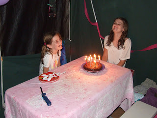
Cape York is an amazing place. As we drove here over the sandy dirt track, with many deeply rutted creek crossings, we were constantly being subjected to a changing landscape. Open Savannah gave way to tropical rainforest, to stunning palm forests that had pandanus and grass trees in the under-stories, to high heath lands as we criss-crossed the tail end of the Great Dividing Range. Another river ferry at the Jardine River took us across to the final section of sandy track to the top of the Cape. We saw our first dingo on the road and snake number 10! The Cape is both beautiful and unusual, with several small “villages”, some predominantly Islander and some, local Murri people. Russ has learnt more about the history of the place so I’ll let him explain the why and wherefores. The stand out feature is the islands, which lie just off the coast. At least ten or more islands seem just a stones throw away. It is incredibly beautiful, with colourful sunsets, fish jumping, white sandy beaches fringed with coconut palms and strewn with shells. The water is an inviting azure colour and the temperature is hot…but no no no, can’t swim “ACHTUNG…Crocodiles!” Oh Pooh! We stayed on croc watch as Russ quickly jumped in near the pier. The water is very shallow everywhere else, so deep water is hard to find. Arieh and the girls have spent a few days fishing off the pier, catching several small bait fish (sardines), but nothing substantial. Saturday was Miss Maeve’s birthday and Arieh and I had managed to make a delicious chocolate cake. We had pancakes for breakfast and then headed off to the tip of the continent for lunch. The ‘tip’ is about a 45 minute drive from Seisia, the village we are camped in. The drive is through more stunning rainforest, along a sandy dirt track. Once at the beach there is a 20 minute walk over a rocky point to the famous marker. We lunched on the beach and headed home for an Indian meal that was beautifully prepared by Russ. The cutting of the cake and a game of Uno finished off a lovely day.  


Saw our second crocodile just off the beach from where we were camped. An interesting statistic....4 out of 5 visitors to the Cape require new thongs!